


GR 400 le Falgoux le Fau

taguette
User
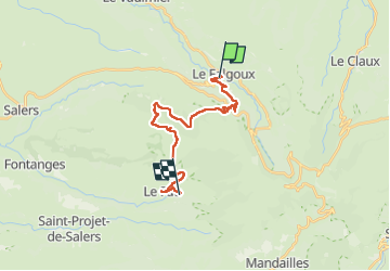

Length
20 km

Max alt
1576 m

Uphill gradient
956 m
Km-Effort
33 km

Min alt
888 m

Downhill gradient
894 m
Boucle
No
Creation date :
2024-08-27 05:36:22.857
Updated on :
2024-08-27 14:56:10.569
7h58
Difficulty : Very difficult

FREE GPS app for hiking
 SityTrail
IGN / Geographical institutes
SityTrail Plus
The world is yours!
About
Trail Walking of 20 km to be discovered at Auvergne-Rhône-Alpes, Cantal, Le Falgoux. This trail is proposed by taguette.
Positioning
Country:
France
Region :
Auvergne-Rhône-Alpes
Department/Province :
Cantal
Municipality :
Le Falgoux
Location:
Unknown
Start:(Dec)
Start:(UTM)
470140 ; 5000044 (31T) N.
Comments